Portage/Ogden Dunes Station
South Shore Line
Portage & Ogden Dunes, Indiana
Last Updated: October 2023
TOD Strategic Implementation Plan
Following the TDD boundary being established October 31, 2022, the team worked closely with the City of Portage and Town of Ogden Dunes to identify and collaboratively advance planning for the community to be proactive about future TOD.
At the conclusion of this process, control of local land use and zoning remains with the cities and towns. This process aims to provide proactive guidance and recommendations that the local units can use to advance their planning processes, resulting in updated comprehensive plans, area plans, and zoning ordinances complete with locally-controlled public input.
Community Priorities & Opportunities
Big Moves
“Big Moves” are defined as enabling steps to signal to the market that conditions are right for transit-oriented development to occur.
Opportunities for medium-density mixed-use transit-oriented development exist in close proximity to the station area. Enhanced connections for pedestrians should link existing suburban neighborhoods and existing and future employment centers to the station area. This station presents unique development-ready sites of large City-owned greenfield properties. Streetscape and traffic enhancements of the US 12/Dunes Highway corridor will increase safety and access to and from the station. Development of RDC property holdings will support future transit-oriented development in Portage.

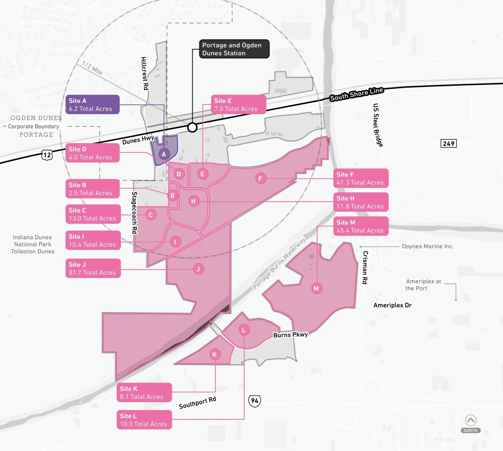

Areas of Impact
Areas of Impact were established to distinguish between major (re)development areas, both TOD and non-TOD, and areas to be maintained, preserved, and enhanced. These designations begin to direct development activity and other targeted investments based on proximity and relationship to the station area.
Vacant land between the utility corridor and existing residential areas presents a “clean slate” for transit-oriented development, although not immediately adjacent to the station. The remaining portions of the boundary to the south present the same “clean slate” opportunity and could accommodate significant development in the future that may build upon the Portage-Burns Waterway, Ameriplex, and interstate access.
Future Land Use
The approach to future land use planning in this plan focuses on areas that are anticipated to change. Future land use is shown in general categories of land use to guide future land use and development decisions while allowing for flexibility in densities and building types.
Land adjacent to the Portage/Ogden Dunes Station is intended to be Station Area uses consisting of surface parking lots serving NICTD rail commuters, but there is potential for Mixed-Use Joint Development over time with structured parking that serves both the development and rail commuters. The remainder of the site is considered to be Conservation-Style Development and Employment/Office uses, with existing Utility Easements as designated.
Land Use Planning


Development Planning
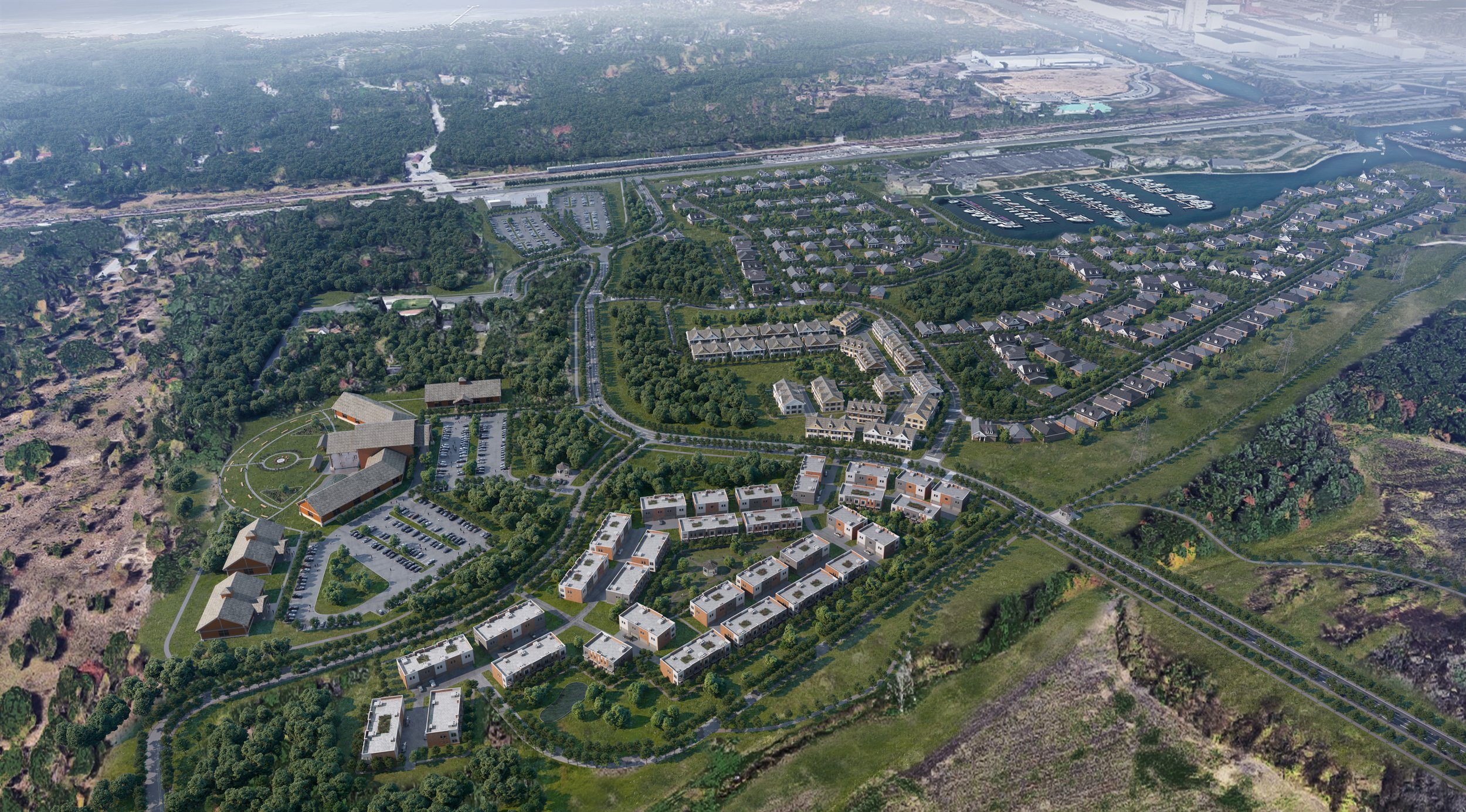
Development Concepts
Six development opportunities were studied in this planning process and selected to illustrate the potential of TOD in more detail with scenario planning and renderings.


Conceptual Rendering of development between in the City of Portage south of the station.
Arc of Development
The arc of development for each community was defined collectively for selected development opportunities within the TDD boundary that projects future development potential over 5-, 10-, and 20-year time horizons. Quantitative and qualitative factors such as local/public property control, developer engagement or interest, site conditions, current regulations or future regulatory changes, among others were considered.


Infrastructure
Thoroughfare Typologies
Thoroughfare Typologies were developed to analyze existing corridor conditions and create aspirational goals for future street design and streetscape.


TOD Priority Thoroughfares
The TOD Priority Thoroughfares in Portage and Ogden Dunes consist of segments of existing and planned roadways: Burns Parkway/Stagecoach Road and its future extension north, and portions of Hillcrest Road and US 12/Dunes Highway that lie within the TDD boundary. The remainder of US 12/Dunes Highway and Hillcrest Road outside of the TDD boundary are TOD Connectors as they connect the surrounding areas to the station area.
There is potential that US 12/Dunes Highway from Lake/Porter County Line Road to Michigan City could be designated as a National Scenic Byway in the future. This designation would position these communities for enhanced tourism as the primary access point to Indiana Dunes National Park. This may also present an opportunity significantly reduce truck traffic by re-routing through trucks to US 20/Melton Road and other major highways.
Thoroughfare & Streetscape Design
Further studies were conducted on TOD Priority Thoroughfares at the request of the local units. These studies and the corresponding order of magnitude cost estimates are included in determining possibilities for infrastructure improvements that could catalyze TOD close to the station.

Conceptual sketch of improvements to Dunes Highway and Stagecoach Road/the future Burns Parkway, including signalized intersections and improved pedestrian facilities.

Questions or Comments
Fill out a comment card - Contact Us
Check the FAQ section
Read through the questions below from the virtual public meeting
Browse through more information on the site which is constantly being updated
Virtual Public Presentation
See below for the full slide deck and video recording from the Virtual Public Presentation on February 3, 2021

Q&A
Does a TDD work like a TIF and capture all increments of AV?
In terms of property tax assessed value, a TIF can be specifically directed to collect real property increment, or it can collect business and personal property increment, or both. The law would allow TDD to do the same.
Are you going to use eminent domain on any of the properties south of US Hwy 12?
The TDD legislation does not give the RDA the power of eminent domain.
How is developing undeveloped land "preserving open spaces." Or, does turning tree filled land into a parking lots considered creating open spaces?
Though the Transit Development Districts are obviously linked to the expansion of commuter rail in Northwest Indiana, issues of rail construction, station location, parking lots, etc., are not within the scope of this TDD process. Our goal is to draw the boundaries of the districts to best realize the development goals and vision of the communities, and enable them to take the best possible advantage of the South Shore as an economic engine for their city or town. If you have a question or comment regarding the rail project, please visit www.doubletrack-nwi.com.
What are Ogden Dunes’ growth goals since we are residentially limited?
The TDD boundary is intended to recognize, document, and be influenced by each city or town's economic development goals. In the case of Ogden Dunes, we worked with town leadership to understand economic development goals.
There is no mention of the importance of the Ogden Dunes beach to our community. Why? What can you do to help us with that rather than giving us a restaurant? (See answer below)
We need help with our beach, not a new restaurant or cute coffee shop. The restaurant in Marina Shores cannot stay open consistently. Why are we not mentioning the beach which is the draw to our community?
We understand that the beach is important to residents of Ogden Dunes. The draft TDD deliberately avoided impacts to the beachfront properties, understanding that the community would want to preserve the residential character there. Moreover, the areas we have identified would create potential to build the tax-base of the community. Please let us know if you would like us to reconsider any properties included in the draft boundary. That’s what this process is all about.
Increased ridership and development of the area would increase traffic to the area. The Miller station today has a similar layout (large parking lot south of 12) and the pedestrians just run all over 12 when trains arrive. What is planned to help efficiently route vehicle and pedestrian traffic with all of the new development?
The new development that would happen in the TDD along U.S. 12 would likely generate traffic south of U.S. 12 and would not generate significant pedestrian traffic across the highway. Any development north of U.S. 12 would likely be self-contained within the community, with options to walk, bike or drive there and would not require crossing U.S. 12 on foot. Safe crossings for commuters across U.S. 12 is being studied by both NICTD and the Indiana Department of Transportation (INDOT).
The TDD process does not increase our taxes but helps the town to possibly make changes if the town wants them?
Yes. The boundary is a tool that captures revenue from incremental growth in future years, not a new tax. That revenue can then be reinvested by the community within the boundary.
US 12 is a sacred part of the community of OD too that does not need growth. Why do you feel we need growth here when there are several communities nearby that we support?
That might be the case. We see most of the opportunity south of U.S. 12 that Ogden Dunes may want to explore. North of 12 is a different story and if the town and its residents feel that growth is not warranted in that area, we can certainly adjust the boundary to reflect that.
How much influence you do have in design/land use/etc. with everything you say is NICTD’s domain?
The town will retain local land use and zoning controls over property within the TDD. Parking lot land use is within NICTD's control. However, there is potential for the community work with NICTD, the City of Portage, and the RDA to seek future joint development that could replace South Shore surface lots with a parking structure, and free up more land for commercial development along U.S. 12.
Are there plans to widen U.S. 12 to accommodate this expansion of the parking lot?
That would be a question for NICTD and INDOT.
If the town wants to develop a small business area, what support do you provide?
Examples of what the TDD could provide include funding for infrastructure improvements that would serve a small business, and incentives for construction of facilities tailored to professional or commercial small businesses.