
Main Street Station
West Lake Line
Munster & Dyer, Indiana
Last Updated: October 2023
TOD Strategic Implementation Plan
Following the TDD boundary being established October 31, 2022, the team worked closely with the Town of Munster and Town of Dyer to identify and collaboratively advance planning for the community to be proactive about future TOD.
At the conclusion of this process, control of local land use and zoning remains with the cities and towns. This process aims to provide proactive guidance and recommendations that the local units can use to advance their planning processes, resulting in updated comprehensive plans, area plans, and zoning ordinances complete with locally-controlled public input.
Community Priorities & Opportunities
Big Moves
“Big Moves” are defined as enabling steps to signal to the market that conditions are right for transit-oriented development to occur.
The Towns of Munster and Dyer aim to transform several greenfield sites into mixed-use transit-oriented development walkable to the station, increase connectivity and mobility by improving and extending Main Street to the station, and strengthening existing residential neighborhoods with a variety housing types near the station. There is long-term potential for joint development at the station area to incorporate mixed-use development into commuter parking.


Areas of Impact
Areas of Impact were established to distinguish between major (re)development areas, both TOD and non-TOD, and areas to be maintained, preserved, and enhanced. These designations begin to direct development activity and other targeted investments based on proximity and relationship to the station area.
The direction of development for this plan identifies the greenfield to the west of the station in Munster and some residential uses to redevelop focusing on TOD investment. Other Areas of Significant Change that are not considered TOD include planned or ongoing redevelopment of industrial areas in Munster to the north, Maple Leaf Crossing (Site C) and Centennial Village (Site B). The future planned medical office on the north side of Main Street (Site A) is a nearly 68-acre development that is walkable to the station. In Dyer, undeveloped vacant land along Calumet Avenue (Site D) has the potential for impactful development that is adjacent to Dyer Central Park.
Future Land Use
The approach to future land use planning in this plan focuses on areas that are anticipated to change. Future land use is shown in general categories of land use to guide future land use and development decisions while allowing for flexibility in densities and building types.
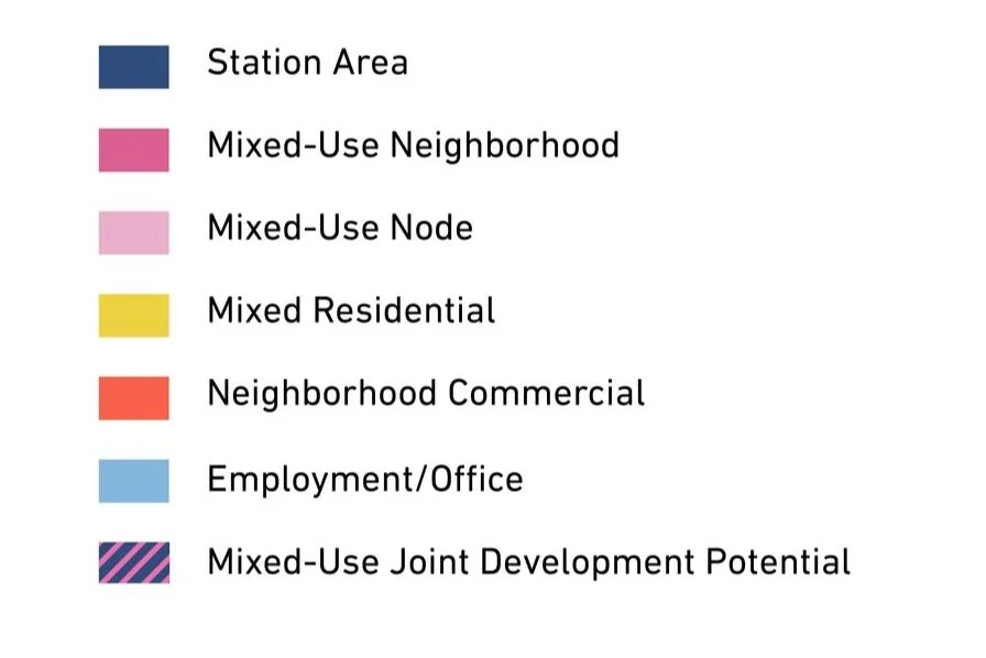
Land immediately adjacent to the future Main Street Station is intended to be Station Area uses that consist of surface parking lots for rail commuters. A portion of this Station Area has the potential to transition to Mixed-Use Joint Development over time that includes mixed-use and parking for commuters. Future land use around the Station Area focuses on Mixed Residential that complements existing residential neighborhoods. In Dyer to the south, areas along the Sheffield Avenue and Calumet Avenue corridors have potential for redevelopment as Mixed-Use Nodes. In Munster to the north, future development is anticipated as Mixed-Use Neighborhood and Employment uses.
Land Use Planning

Development Framework
Development Concepts
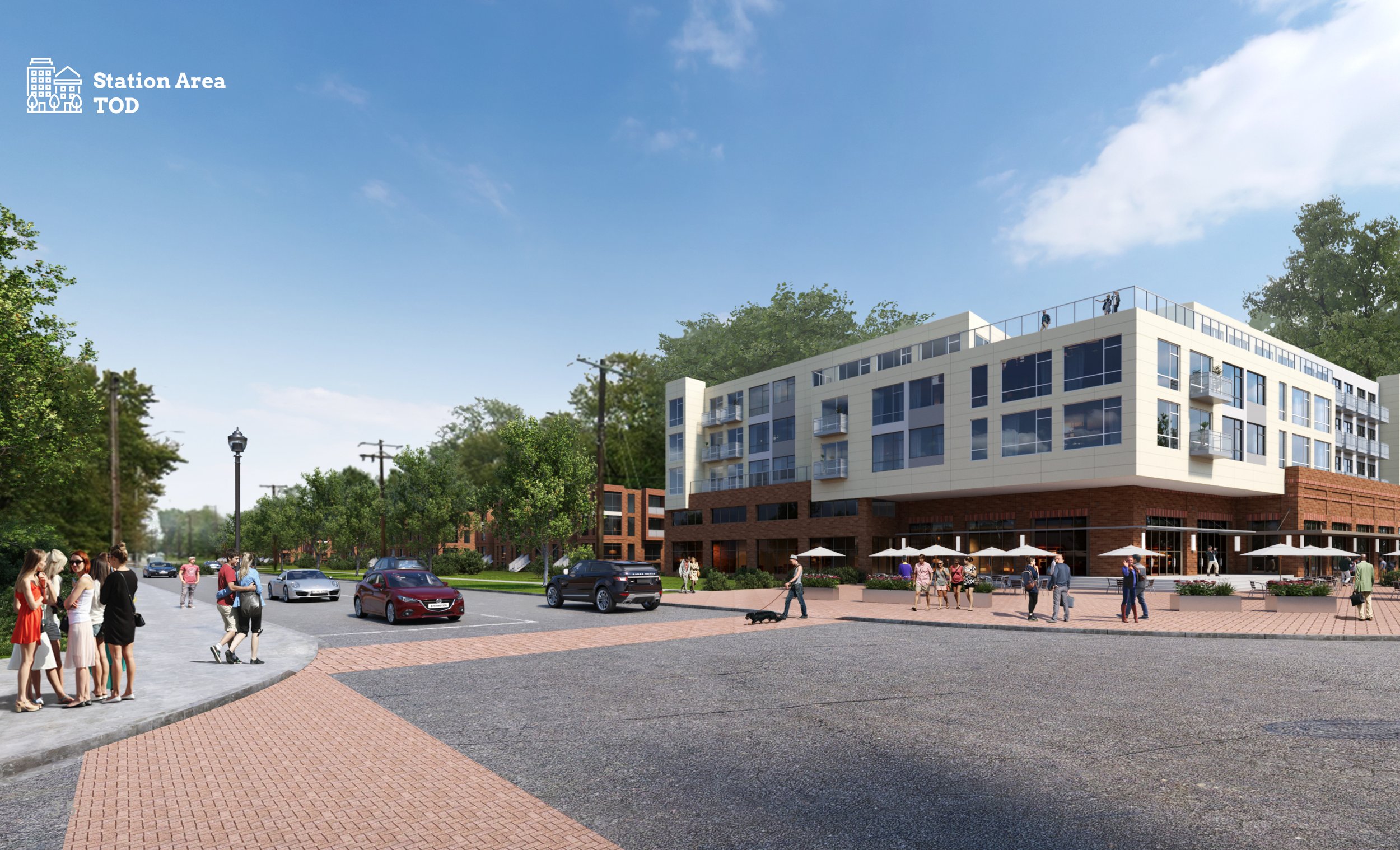
Four development opportunities were studied in this planning process and selected to illustrate the potential of TOD in more detail with scenario planning and renderings.


Conceptual Rendering of development near the Main Street Station in Dyer (Site G)
Arc of Development
The arc of development for each community was defined collectively for selected development opportunities within the TDD boundary that projects future development potential over 5-, 10-, and 20-year time horizons. Quantitative and qualitative factors such as local/public property control, developer engagement or interest, site conditions, current regulations or future regulatory changes, among others were considered.


Infrastructure
Thoroughfare Typologies
Thoroughfare Typologies were developed to analyze existing corridor conditions and create aspirational goals for future street design and streetscape.


TOD Priority Thoroughfares
A portion of Main Street and the future extension of Main Street are designated as a TOD Priority Thoroughfare as it is the only road that leads to the station area. Calumet Avenue, Columbia Avenue, Sheffield Avenue, and other portions of Main Street are TOD Connectors that connect to Main Street and the station area. 45th Street and 213th Street are Key Vehicular Routes that carry traffic from the community to the TDD boundary, connecting to important thoroughfares. Key Pedestrian Routes are crucial to connect potential new development and the station area with the Pennsy Greenway.
Thoroughfare & Streetscape Design
Further studies were conducted on TOD Priority Thoroughfares at the request of the local units. These studies and the corresponding order of magnitude cost estimates are included in determining possibilities for infrastructure improvements that could catalyze TOD close to the station.


The vision for Main Street enhancements is to establish a consistent right-of-way and a continuous curb condition with planting, lighting, and pedestrian space characteristic of a typical “main street”. Proposed elements include a multi-use path, street trees and lawn, planted median, on-street parking, seating, bike racks, and wayfinding.
Questions or Comments
Fill out a comment card - Contact Us
Check the FAQ section
Read through the questions below from the virtual public meeting
Browse through more information on the site which is constantly being updated
Virtual Public Presentation
Review the full slide deck and video recording from the Virtual Public Presentation held on December 2, 2020.

Virtual Public Presentation
Review the video recording from the Virtual Public Presentation held on March 1, 2022.
Q&A
The commercial properties surrounding mine are all included in the draft TDD boundary; however ours was not. What is the process for requesting reconsideration of the boundary in this scenario?
Any questions about the TDD boundary can be submitted through the contact form on this website or directly to RDA Communications Manager Dave Wellman at dwellman@rda.in.gov.
What specific revenue requirements does Munster have that cannot be met by existing revenue mechanisms and TIF and that required the development of this new tool?
A TDD captures not just property tax increment, but income tax increment as well, so in that respect it is a broader tool for a economic development. In some cases, a TDD could also have a longer life than a tax increment financing (TIF) district, so in cases where the TDD overlaps with a TIF in could extend the window for development once the TIF district expires. The TDD also allows for bonds to be issued through the Indiana Financing Authority (IFA) in a way that does not negatively impact an individual communities debt ceiling and may offer favorable interest rates.
Munster does not need a TDD to pay for existing obligations. The town has an excellent track record of meeting all of its debt service and has a phenomenal bond rating. Munster did not create the TDD, it was part of legislation passed by the Indiana General Assembly. This tool will allow Munster to facilitate the kind of development that the community wants to see, especially the kind that is not developer-driven such as parks and open space.
Is any debt proposed to be issued by the TDD subject to the same constitutional limit of 2% of AV like municipalities?
The TDD legislation allows the RDA to use the revenue that comes from the increment to pay debt service on bonds that would be issued by the RDA through the IFA. Those bonds would not be on the community’s balance sheet and would not count against the community’s 2% debt limitation.
Has there been any thought about how the proximity of the Lansing Municipal Airport might affect development?
The Lansing Municipal Airport is not with the Town of Munster, so it is not eligible for inclusion in the TDD. However, there is potential for development.
The Lansing Municipal Airport is not with the Town of Munster, so it is not eligible for TDD inclusion. However, there is potential for development complementary to the services offered by the airport. There are several parcels within the Town of Munster which have airport-related height restrictions. Areas within the TDD will be controlled by local land use and zoning, which include airport-related regulations.
What about the potential positive impact of having some type of intermodal connection between the airport and rail?
There could be new infrastructure related to streets, trails and multimodal transportation implemented in the next several years in part due to efforts by communities to make connectivity improvements, traffic and pedestrian demands tied to the Main Street station, and future development. The establishment of a TDD can help communities fund future infrastructure improvements. Improvements outside of the TDD, such as to the Lansing Airport would need to be funded by other sources.
Will the Cambridge Court Condos on Fisher be negatively impacted by train noise or land use?
Any concerns regarding train noise should be directed to NICTD at www.nictdwestlake.com. Regarding land use, local land use and zoning controls will remain with the Towns of Munster and Dyer after the Transit Development District (TDD) is established. Throughout this process, the RDA met with local leadership to understand community land use-goals.
To what extent will you consider planning to make it easy and feasible to bike or walk to the train station?
Munster has submitted to Northwestern Indiana Regional Plan Commission (NIRPC), the regional planning agency that is responsible for distributing federal funds for road improvement, a joint application with Dyer, Schererville and Highland to redesign Main Street specifically to facilitate the inclusion of bike lanes and sidewalks, making it a complete street.
What consideration has been made to the obvious changes in the business environments, working from home? The interests and needs may change completely.
The RDA is aware of changes to the business environment being experience as the result of COVID-19. The TDD is a long-term economic development tool that is established to provide tools to allow communities to realize development in anticipation of future demand. The RDA is working with a team of economic development and public financing specialists to study both short-and long-term impacts of COVID-19 and what opportunities may exist.
What is the schedule to address other communities involved in the project (beyond Munster, Dyer and Ogden Dunes)?
The RDA is actively working with all the Double Track and West Lake Communities, as highlighted in the presentation, to advance draft TDD boundaries to a place where public input could be sought. We anticipate meeting with the rest of the communities with TDD's throughout the rest of 2020 and 2021. Information about these meetings will be posted on the website, local news, and the RDA's and community's social media.
Will Margo Lane be open or remain closed to the new parking lot for the Munster south station?
The Double Track and West Lake rail construction, station location, parking lots, etc., are not within the scope of this TDD process; they are under the jurisdiction of NICTD. Specifically, any proposed extension of Margo Lane would need to be negotiated directly between NICTD and the Town of Munster. At this time, we are not aware of a Margo Lane extension being planned as part of NICTD's project. If you have a question or comment regarding the rail project, please visit nictdwestlake.com.
Which group will be tasked with working on any extension of Main Street into Illinois?
The extension of Main Street into the State of Illinois requires bi-state and local coordination. The TDD, once established could be a tool to help with infrastructure improvements within the TDD, but the extension of Main Street is not part of the process of establishing this economic development district.