Gary Miller Station
South Shore Line
Gary, Indiana
Last Updated: October 2023
TOD Strategic Implementation Plan
Following the TDD boundary being established October 31, 2022, the team worked closely with the City of Gary to identify and collaboratively advance planning for the community to be proactive about future TOD.
At the conclusion of this process, control of local land use and zoning remains with the cities and towns. This process aims to provide proactive guidance and recommendations that the local units can use to advance their planning processes, resulting in updated comprehensive plans, area plans, and zoning ordinances complete with locally-controlled public input.
Community Priorities & Opportunities
Big Moves
“Big Moves” are defined as enabling steps to signal to the market that conditions are right for transit-oriented development to occur.
Redevelopment sites adjacent to the station area have the potential for medium-density mixed-use TOD, including several City-owned sites. Enhancing walkability, in addition to recent streetscape improvements along Lake Street, is important to connect existing traditional neighborhoods and commercial corridors to the station area. Realignment of US 20/Melton Road will increase developable land immediately surrounding the station area. TOD sites support high-quality, dense housing to increase the residential population in the Miller Station Area.


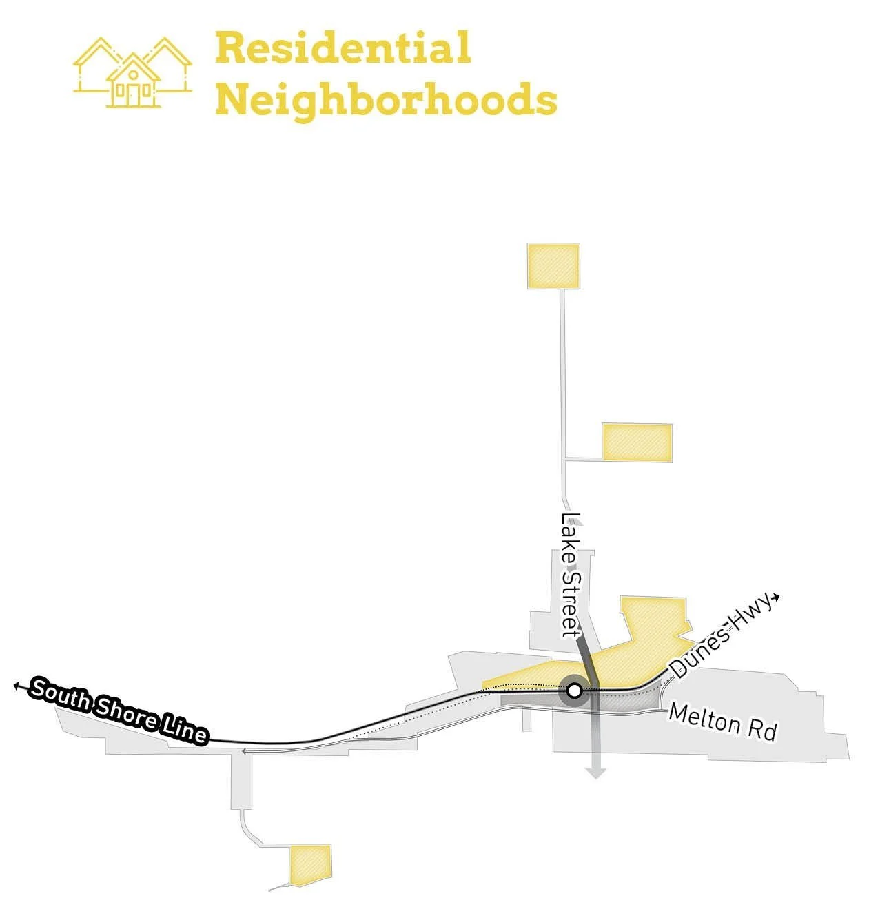
Areas of Impact
Areas of Impact were established to distinguish between major (re)development areas, both TOD and non-TOD, and areas to be maintained, preserved, and enhanced. These designations begin to direct development activity and other targeted investments based on proximity and relationship to the station area.
The Gary Miller Station Area presents a critical mass of transit-oriented development opportunities in close proximity to the station because of the large amount of vacant or underutilized land around the South Shore Line, including many properties owned by the City of Gary. Additional infill north of the station could complement the building activity of the Lake Street commercial corridor.


Future Land Use
The approach to future land use planning in this plan focuses on areas that are anticipated to change. Future land use is shown in general categories of land use to guide future land use and development decisions while allowing for flexibility in densities and building types.
Future land uses anchor the intersection of Lake Street and the South Shore Line with Mixed-Use Neighborhood. Long-term Mixed-Use Joint Development of surface commuter parking areas could occur directly south of the rail in collaboration with NICTD. Smaller pockets of Mixed-Use Neighborhood would create new destinations along Miller Avenue and around the former Old Miller Town Hall building. Mixed Residential development has the potential to strengthen existing neighborhood grids and key opportunities at the former Aetna School and the former Wirt High School. The former armory site at Miller Beach is suited for Mixed Residential development and Conservation Area, protecting beachfront land and views. Employment/Office uses south of US 20/Melton Road would complement existing uses.
Land Use Planning
Development Framework
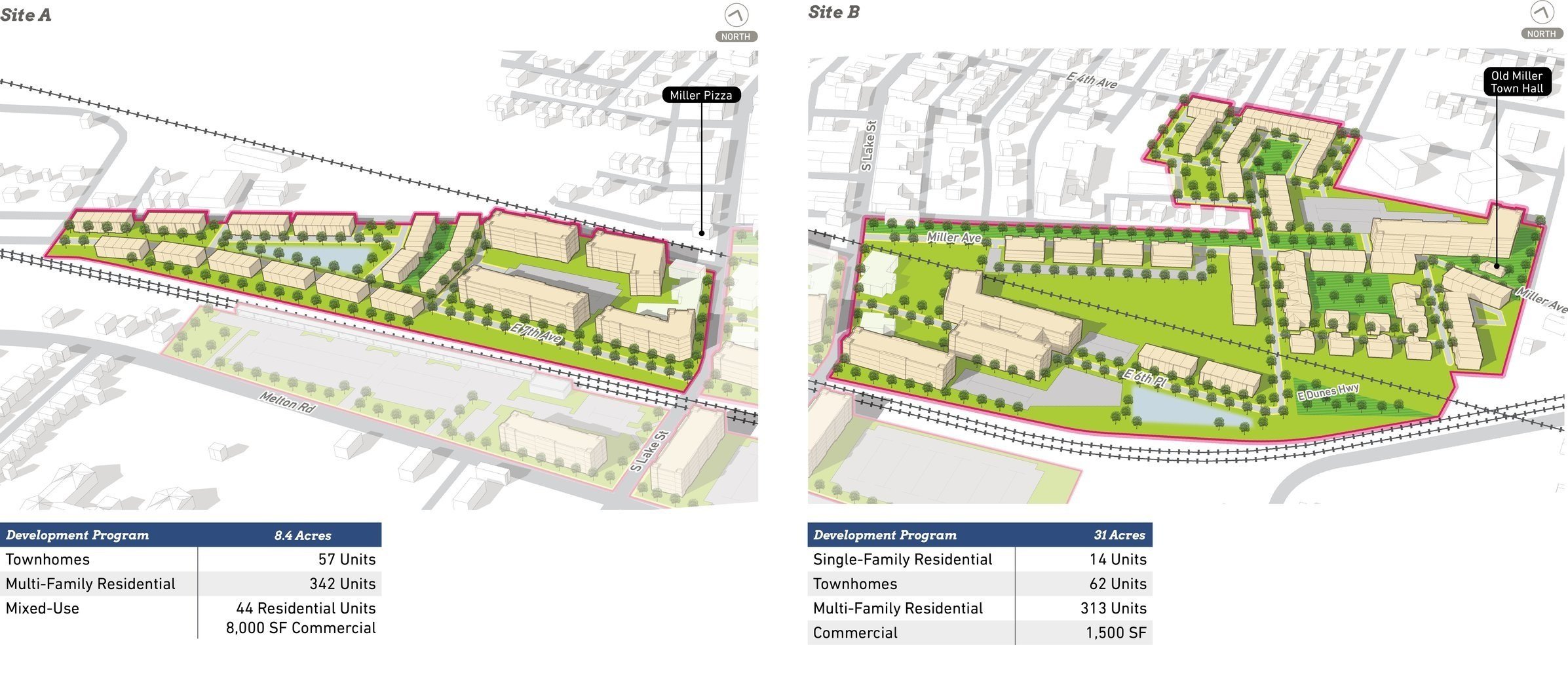
Development Concepts
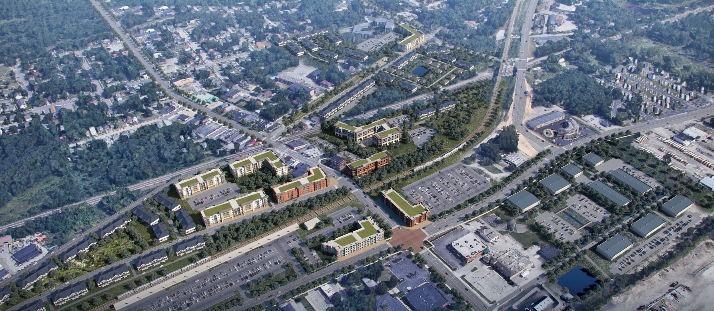
Five development opportunities were studied in this planning process and selected to illustrate the potential of TOD in more detail with scenario planning and renderings.


Conceptual Rendering of development around the Miller Station Area


Conceptual Rendering of a redesigned Miller Avenue (Site B)
Arc of Development
The arc of development for each community was defined collectively for selected development opportunities within the TDD boundary that projects future development potential over 5-, 10-, and 20-year time horizons. Quantitative and qualitative factors such as local/public property control, developer engagement or interest, site conditions, current regulations or future regulatory changes, among others were considered.

Infrastructure
Thoroughfare Typologies
Thoroughfare Typologies were developed to analyze existing corridor conditions and create aspirational goals for future street design and streetscape.


Thoroughfare & Streetscape Design
Further studies were conducted on TOD Priority Thoroughfares at the request of the local units. These studies and the corresponding order of magnitude cost estimates are included in determining possibilities for infrastructure improvements that could catalyze TOD close to the station.


Design concepts for Miller Avenue include re-capturing an abandoned railroad right-of-way and an alley and transforming this corridor into a linear park with trail connectivity, flexible and programmable open space, placemaking elements, and a landscaped plaza.
Thoroughfare Typologies
Designated as TOD Priority Thoroughfares, Lake Street (south of 3rd Street) and US 20/Melton Road (between Aetna Street and the new US 12/Dunes Highway intersection) serve as the primary access routes to and from the Gary Miller Station. The northern portion of Lake Street, Hemlock Avenue, and Miller Avenue are TOD Connectors that create connections to the Lake Street commercial corridor. Two rail crossings exist in Miller; the primary crossing at Lake Street, and a secondary crossing needs upgrading at Old Hobart Road. US 12/Dunes Highway, US 20/Melton Road, Aetna Street, and Grand Boulevard are Key Vehicular Routes through the TDD boundary. Still, pedestrian safety and connectivity will also be important for these corridors near the station area. Miller Beach is connected regionally via the Marquette Greenway to the east of Grand Boulevard, with a proposed extension to continue westward into Indiana Dunes National Park and Marquette Park. Key Pedestrian Routes include Lake Street, Miller Avenue, and other smaller routes to access residential areas that promote walkability within this future mixed-use core around the station.
Questions or Comments
Fill out a comment card - Contact Us
Check the FAQ section
Read through the questions below from the virtual public meeting
Browse through more information on the site which is constantly being updated
Virtual Public Presentation
See below for the full slide deck and video recording from the Virtual Public Presentation on February 11, 2021:

Q&A
So according to your walk-through of the boundaries, they are not "gerrymandered." Could you please elaborate on this?
The boundaries are set based on the goals of the community and where the goals can best be accommodated within the Gary Miller area. We’re building this around good candidates for redevelopment and around areas that should be strengthened. We analyze various conditions and infrastructure at a high level to better understand where these funds can also help drive development. A good amount of the boundary has been formed in collaboration with city leadership.
This is great information. Who isn’t at this meeting but should be?
Great question. We try to keep as many people involved as possible. We have the Zoom call as well as broadcasting live on Facebook and will be up on Facebook after. We appreciate those of you viewing live and hope you will share with others. We also have a web page www.nwiTDD.com which we keep updated with events and information. There are also boards printed for people interested to view the information in person, located at the Marquette Pavilion.
Why does it have to have a boundary? Is this like phase 1?
These districts need to have a boundary for it to be utilized as an economic tool to get approval to reinvest incremental economic growth to collect the revenue to then be reinvested within the same boundary. This is the first area within the boundary that, by statute, cannot be over 320 acres. At a later point, there is the possibility to grow this boundary to 640 acres to capture a larger area of incremental growth to invest back into those areas and new ones.
How have these plans been tweaked post COVID-19?
Although COVID-19 has certainly changed a lot of how we look toward the future, our objective is still to create areas that are resilient and encourage live, work, play environments so that they can withstand not only health crises as best as possible but economic downturns as well. The boundaries are all strategic to plan for growth and stabilization.
Was systemic racism thought about while looking at all the old plans?
We recognize this is an important topic in the planning that we do so we do look to the plans that city has put in place but we also want the boundary to be equitable and for all people to have proximity and advantage to transit so job opportunities and more.
What would the cost of this housing (In regard to photos of potential residential development shown during the public presentation)?
The housing typologies are not specific just yet so there are no proposals or particular developments just yet that directly relate to these photos. This is really about defining the boundary so it gets adopted and development can occur over time.
Do they have developments in mind already? If so, what if not what do they hope to see?
The city has done a good job laying the path for types of development they want to see happen which includes a diversity of a wide range to help strengthen the community and create resiliency.
Is there a community-based agreement of some sort?
An MOU, Memorandum of Understanding is agreed upon between the RDA and the city or town to set in place specifics of the increment collected, overlaps with other investment or overlay zones, and other commitments or incentives for projects.
How will the old Highway 12 span be used?
There will be a portion of the rail line that will be vacated and a portion of old Highway 12 will be used to straighten the bend for faster commute times and some will be available for a larger station area and more developable area near the tracks.
When can the boundary be expanded to capture neighborhoods needing and having opportunities for stabilization and needing infrastructure?
The timeline to expand the boundary is not yet set but comments and considerations from this meeting and with city leadership could include areas in the first boundary or decide that these areas are better suited to add when the boundary allows for expansion.
If the Downtown Gary Metro Station is part of these studies, has it been taken into consideration from a connectivity standpoint with the Miller Station? Seems a no-brainer to have synergies between the two stations, particularly one in the center of the downtown district.
The formation of the boundary for the Gary Metro Station has started. Certain areas that were once included in the Miller boundary have been determined to be more suited for Gary Metro. Coordination and synergies between the two stations are being considered.
Is this a TOD (transit-oriented development) or a TON (transit-oriented neighborhood)? Is housing going to have options such as multi-generational, flex space/live work, and green aspects?
The boundary itself is a transit development district and within that are many different potential developments and land use types depending on the demand and the opportunities of the areas. It could be more of a neighborhood typology but in this case, we are looking to the city’s goals for growth.
It seems like there is a lot of investment here with the TDD, US20, Lake St, and the SoShore. The City of Gary has done a great job getting this investment.
This is a great point and there are a lot of different agencies that are participating in putting a real focus in this area so we are excited about more opportunities and growth to come.
You say leadership. Who is that specifically?
We have worked with a lot of city staff and people from the Mayor’s office as well as representatives from engineering, zoning, planning, and more.