

Gary Metro Station
South Shore Line
Gary, Indiana
Last update: October 2023
The Gary Metro Transit Development District Boundary was established effective October 27, 2023.
PROJECT UPDATES
Station Area Summary

TDD Boundary Summary
The resulting TDD boundary for the Gary Metro TDD station area focuses on three future investment strategies: Station as a Catalyst, Improving Station Access, Redefining Broadway, and Property Control. The redevelopment of Gary Metro Center and its neighboring sites will anchor proposed future development for downtown Gary. Parallel to this process, the City should continue to acquire under-performing or vacant properties in strategic locations. The City should target properties within the core of the downtown area located on prime developable property for demolition, stabilization, and a blend of subsidized and market-rate development. As a second phase, priority sites in close proximity to the Gary Metro station, including that occupied by the Genesis Convention Center today, could form a mixed-use development core. Southern sites along Broadway Avenue form a corridor for future commercial and mixed-use development. Further expansion includes future neighborhood commercial development bookended by the Railcats Stadium on the east, Jackson Park on the West, and down Broadway to 8th Avenue. Within this process, contributing historical buildings in good condition could be candidates for historic preservation and/or adaptive reuse. The goal is to create a critical mass of development in the core of Downtown Gary that can create a market around TOD and support the City’s economic development path.

Introduction
The Gary Metro TDD (315.5 acres) benefits from the momentum to revitalize Downtown Gary through targeted infrastructure improvements, blight elimination, and community-focused redevelopment in partnership with state, regional, and local partners. The TDD is envisioned to take advantage of State Funding provided by SB 434, which became law in 2023 and funds a blight elimination matching grant program and multi-modal station replacement matching grant program. Such an investment will spearhead and support revitalization and economic development efforts in Downtown Gary. The Northwest Indiana RDA will administer this program. More information about this legislation can be found here. A revitalized Gary Metro Station block has the potential to create immense opportunity or equitable transit-oriented development throughout Downtown Gary. By prioritizing a new multi-modal station area and capitalizing on property in public control, a multi-pronged approach to redevelopment should be pursued. Walkable pedestrian-scaled street corridors and paths that link to existing and planned local and regional trail systems could capitalize on Gary’s prime location in the region. Phasing and prioritizing redevelopment and improvements are crucial to ensuring Gary’s sustainable growth and revitalization, catalyzed by the Gary Metro Station.
Development Opportunities
The map to the left shows potential development opportunities within the TDD Boundary.
TOD Strategic Implementation Plan
The team worked closely with the City of Gary to identify and collaboratively advance planning for the community to be proactive about future TOD.
At the conclusion of this process, control of local land use and zoning remains with the cities and towns. This process aims to provide proactive guidance and recommendations that the local units can use to advance their planning processes, resulting in updated comprehensive plans, area plans, and zoning ordinances complete with locally-controlled public input.
Community Priorities & Opportunities
Big Moves
“Big Moves” are defined as enabling steps to signal to the market that conditions are right for transit-oriented development to occur.
Downtown Gary and the greater metro area present the opportunity for equitable, transit-oriented development. A phased anchor-based approach should be implemented, targeting the blocks around the Gary Metro Station and the Genesis Convention Center. This effort should co-locate community resources within existing anchors. Broadway Avenue should be enhanced with a Complete Street design, including multi-use paths to increase pedestrian comfort and safety and connect to future local and regional trails. 4th and 5th Avenues also have the potential for improved pedestrian crossings, a more activated public environment, and a Complete Street design to accommodate more modes of travel. In addition, a conversion to two-way traffic will help calm traffic and make the streets more friendly to all users. In the short term, tax credit development in collaboration with Gary Housing Authority could lead to investments as an enabling step to show visible improvements in the downtown area leading to long-term infrastructure investments.


Areas of Impact
Areas of Impact were established to distinguish between major (re)development areas, both TOD and non-TOD, and areas to be maintained, preserved, and enhanced. These designations begin to direct development activity and other targeted investments based on proximity and relationship to the station area.
The Downtown Gary TOD area provides a generational opportunity to uplift Gary by replacing the aged Metro Station. When combined with a development strategy that prioritizes equitable, transit-oriented development and improves existing community anchors, this effort will provide a significant and long-term improvement to Gary.
Future Land Use
The approach to future land use planning in this plan focuses on areas that are anticipated to change. Future land use is shown in general categories of land use to guide future land use and development decisions while allowing for flexibility in densities and building types.
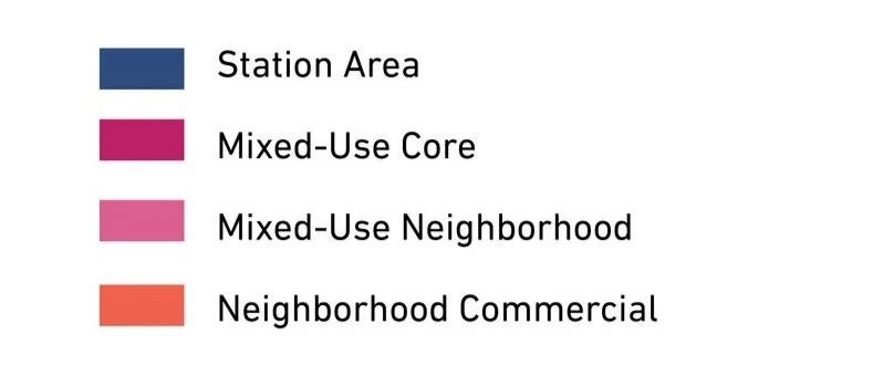
The approach to future land use simplifies the land uses downtown, where TOD has the potential to bring back considerable economic development opportunities, residents, and businesses. This strategy concentrates high-density Mixed-Use Core land uses to the immediate vicinity of the station and key corridors to encourage impactful high-density development. Mixed-Use Neighborhood land uses continue along the blocks surrounding the Broadway corridor south of 6th Avenue. Neighborhood Commercial land uses follow the 5th Avenue corridor east and west of the downtown core.
Other areas adjacent to targeted TOD sites could follow a range of land use recommendations included in the City of Gary Comprehensive Plan.
Land Use Planning


Development Framework
Development Concepts
Seven development opportunities were studied in this planning process and selected to illustrate the potential of TOD in more detail with scenario planning and renderings.


Conceptual rendering of development a new Gary Metro Center Station (Sites A, B C, and D)

Conceptual rendering the new Gary Metro Center Station (Site A)

Conceptual rendering of development and a redesigned Broadway Avenue (Site D)
Arc of Development
The arc of development for each community was defined collectively for selected development opportunities within the TDD boundary that projects future development potential over 5-, 10-, and 20-year time horizons. Quantitative and qualitative factors such as local/public property control, developer engagement or interest, site conditions, current regulations or future regulatory changes, among others were considered.

Infrastructure
Thoroughfare Typologies
Thoroughfare Typologies were developed to analyze existing corridor conditions and create aspirational goals for future street design and streetscape.

TOD Priority Thoroughfares
Broadway Avenue has the most opportunity to transform Downtown Gary from a thoroughfare investment as a TOD Priority Thoroughfare. As the historic heart of the community, this should be envisioned as a Complete Street with on-street parking and high-quality multi-modal and pedestrian amenities. This corridor is also expected to be a significant pedestrian connector from the Marquette Greenway to the planned Gary Elevate Trail. It is also important to locate GPTG bus stops along this corridor, servicing the downtown area.
4th and 5th Avenues as TOD Connectors also prioritize walkability and multi-modal amenities, which the proposed redesign of the pair aims to accomplish.
Thoroughfare & Streetscape Design
Further studies were conducted on TOD Priority Thoroughfares at the request of the local units. These studies and the corresponding order of magnitude cost estimates are included in determining possibilities for infrastructure improvements that could catalyze TOD close to the station.


Design concepts for 4th and 5th Avenues focus on converting one-way traffic into two-way traffic, including medians for traffic calming and improved pedestrian amenities.
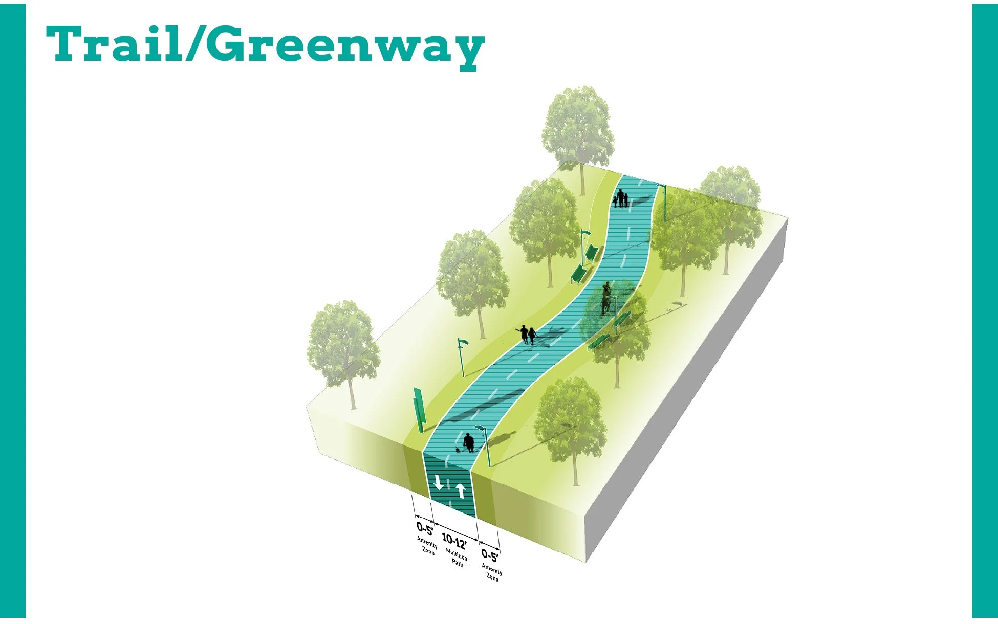
Design concepts for Broadway propose reducing vehicle lanes, installing a median for traffic calming, landscaping and street trees, and bicycle/trail facilities.


Virtual & In-person Public Presentation
Review the full slide deck, gallery, and presentation recording from the Virtual & In-person Public Presentation on September 7, 2023.
Browse through more information on the site which is constantly being updated